OpenFlows StormCAD CONNECT Edition Update 4 (10.04.00.158)
Free Download OpenFlows StormCAD CONNECT Edition Update 4 | 997.1 mb
Product:OpenFlows StormCAD
Version:CONNECT Edition Update 4 (10.04.00.158)
Supported Architectures:x64
Website Home Page :www.bentley.com
Languages Supported:english
System Requirements:Windows *
Size:997.1 mb
The Hydraulics and Hydrology products team is pleased to announce the availability of StormCAD CONNECT Edition Update 4 (10.04.00.158). This release includes enhancements and new features to help you be more successful with your hydraulics and hydrology modeling projects.
StormCAD CONNECT Edition Update 4 (10.04.00.158) - What's new:
2D Modeling
Starting with SewerGEMS and CivilStorm CONNECT Edition Update 4, you can now model a 2D analysis in SewerGEMS, reporting results such as surface flow, surface velocity, and water depth. The 2D analysis can be integrated with the 1D analysis typical of many SewerGEMS modeling. With the 2D analysis, you will be able to model 1D/2D urban flooding, including 2D flow from overtopping structures, and rainfall runoff, including overflows and direct rainfall on terrain. All 2D related elements, input managers, results viewers are located in the 2D Modeling tab in the Ribbon interface.
Watch the below short video for a demonstration of the benefit of this feature. For a longer demonstration, watch this webinar recording.
Improved calculation using Explicit solver with a large number of catalog inlets
If you are using the Explicit solver in SewerGEMS and CivilStorm with a large number of catalog inlets, improvements have been included that reduces the time it takes to compute a model. This improvement will be most effective in large models.
Added HDPE to Engineering Library
The HDPE material type has been included in the Engineering Libraries.
New Loss Methods when Using the Explicit (SWMM) Solver
Two new Loss Methods are included in catchments using the Unit Hydrograph runoff method in the Explicit (SWMM) solver: Horton (Modified) and Green and Ampt (Modified).
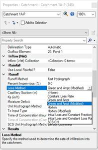
This replaces options to select these methods in the calculation options when using the Explicit solver.
Time Step Export Options Added to Export to Excel Feature
An option has been added to the Export to Excel feature for the user to set the time steps that are exported to Excel.
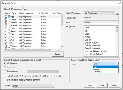
This feature will be useful to limit the number of rows exported out to Excel and decrease the time needed to export the data.
Bulk Archive Feature in Change Tracking
A new bulk archive feature is available for change tracking. With this, you will be able to archive a large number of items from the Change Tracking database. This will remove the items from the model database file and store the archived changes in an external database file. You can access this by going to the Review tab. Note that this does not replace the Archive feature in the Change Tracking manager.

Support for Automated and Manual Catchments in Catchment Delineation
Functionality has been added to automated catchment delineation in the Terrain Models manager to preserve the shape and location of catchments that were added to a model manually. This will help you model catchments if there are any issues with the accuracy of the terrain model. A new property field, Delineation Type, has been added to the catchment properties.
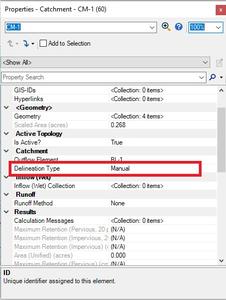
If the Delineation Type is set to Manual, if you run the catchment delineation tool in Terrain Models, the automated catchment that is created or adjusted will not overlap existing manual catchments. In addition, the shape and location of the manual catchments will not change.
Add Sump Depth to Conduit Inverts
An option to account for sump depths when setting conduit invert elevations as been included for all storm-sewer products. In the calculation options, two new fields are included: "Start/Stop Inverts Use Sump Depths" and "Measure Sump Depth To." If "Start/Stop Inverts Use Sump Depths" is set to True and the conduit property "Set Invert to Start" or "Set Invert to Stop" is set to True, the conduit invert elevation will be set as the connected node invert elevation plus the sump depth, assuming that "Measure Sump Depth To" is set to Conduit Invert. If "Measure Sump Depth To" is set to Bottom of Conduit, the conduit invert elevation will also include the conduit thickness. If "Start/Stop Inverts Use Sump Depths is set to False and "Set Invert to Start" or "Set Invert to Stop" are set to True, the conduit invert will equal the node invert.
Infiltration per Catchment Using Explicit (SWMM) Solver
If you are using the EPA-SWMM runoff method, you will be able to model different infiltration methods in different catchments when using the Explicit (SWMM) solver.
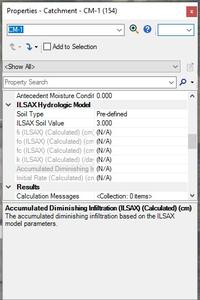
Exposed FI, FID, and INITIAL RATE Properties for ILSAX Catchments
When using the ILSAX runoff method for catchments, properties for FI, FID, and Initial Rate are now available.
Weighted Rational C or CN Calculation from Intersection of Land Cover Polygon with Catchment Area
In the Catchment properties, the "Area Defined By" field has an option for Land Cover Areas. If there are Land Use polygons (found in the 2D Modeling tab of the ribbon) intersecting the catchment, weighted for C and CN will be calculated based on the user-defined or catalog values used in elements.
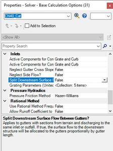
Improved Gutter Flow Results with Multiple Incoming Gutters
A new calculation option has been included where results from multiple gutters discharging into the same In Sag catch basin or outfall. If the calculation option "Split Downstream Surface Flow Between Gutters?" is set to True, the surface flow from the terrain to downstream structure will be allocated to the gutters proportionally by gutter length. This applies to gutters with sections from terrain and discharging to the same catch basin or outfall.
SWMM Control Curves available for SWMM Control Sets
You can now include SWMM Control Curves in SWMM Control Sets. To create these, go to Components > SWMM Extensions > Control Curves.
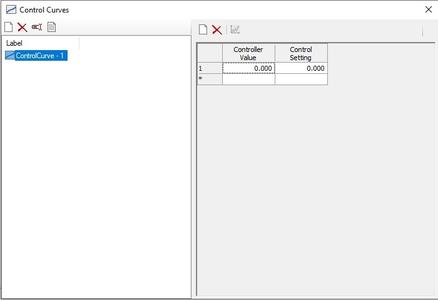
After adding the Control Curve it can be used for the SWMM Control Set for weirs and pumps. For example, a control set for a weir may look like this:
RULE R4A
IF JUNCTION J1 DEPTH >= 0.0
THEN WEIR W2 SETTING = CURVE CurveData-1
Compatibility and General Information
SewerGEMS, CivilStorm, SewerCAD, and StormCAD are compatible with Windows 11, Windows 10, and Windows 8.
The following platforms are supported:
- Standalone (no CAD or GIS software required)
- MicroStation CONNECT Edition
- AutoCAD 2023 and 2022
- ArcMap 10.8 and earlier (SewerGEMS only)
- ArcGIS Pro 2.8.X and 2.9.X (SewerGEMS only)
Models saved in earlier versions of the OpenFlows products can be opened in this version. As with all new versions, this release includes fixes to various user-reported issues from the previous release, providing an overall more stable experience.
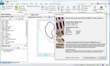
WithOpenFlows WorkSuite, you can confidently plan, design, and operate water systems of any complexity. OpenFlows technologies combine real-time intelligence with spatial analytics, delivering visibility and insights to ensure optimal real-world outcomes. Apply OpenFlows solutions to a wide array of water-related processes, including water distribution and analysis, sanitary and combined sewer management, and flood risk assessment and mitigation.
StormCADis a comprehensive modeling software for the design and analysis of storm sewer systems. With StormCAD, you can calculate catchment runoffs, inlet capacities, and gutters and pipe network flows. StormCAD maintains a single set of modeling files for true interoperability across platforms. Out of the box, you can employ this product as a stand-alone application or work directly from within MicroStation, OpenRoads, OpenSite, or OpenRoads Designer. The stand-alone interface offers easy-to-use model layout tools, multiple background support including Bing aerial imagery, conversion utilities from CAD, GIS, and databases.
Automated Design tips and tricks
Bentley's Martin Pflanz demonstrates the automated design feature available in SewerGEMS, CivilStorm, StormCAD and SewerCAD. Automated Design can quickly provide you with a good starting design for your pipe sizes, inverts, inlet sizes, etc, to meet your constraints such as cover, slope and velocity.
Bentley Systems, Incorporatedis the global leader dedicated to providing architects, engineers, constructors, and owner-operators with comprehensive architecture and engineering software solutions for sustaining infrastructure. Founded in 1984, Bentley has nearly 3,000 colleagues in more than 45 countries, $500 million in annual revenues, and, since 2001, has invested more than $1 billion in research, development, and acquisitions.
Links are Interchangeable - Single Extraction
